Every time you use your car's mapping function to find directions, you're using GPS. Nico De Pasquale Photography / Getty Images
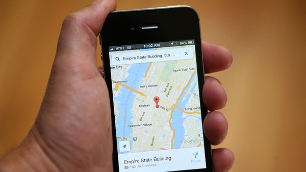
Many of us use GPS pretty much every day — getting directions with mapping apps on our phones, tracking our meal deliveries, logging our running routes — but have you ever stopped to wonder, how does GPS work?
Almost all smart phones utilize GPS technology, so let's figure out what that actually means and why having a GPS receiver and a clear view of the sky means you'll never be lost again.
When people talk about "a GPS," they usually mean a GPS receiver, but the Global Positioning System (GPS) is actually a constellation of many Earth-orbiting satellites (gps.gov/systems/gps/space/">31 in operational orbit and four that are classified as either "in reserve" or "unhealthy").
The U.S. military originally developed and implemented this satellite network as a military navigation system, then opened it up to everybody else.
Advertisement
Each of these 3,000- to 4,000-pound (1,361- to 1,814-kg) solar-powered satellites circles the globe at an altitude of about 12,427 miles (20,000 km), making two complete rotations every day. The orbits are arranged so that at any time, anywhere on Earth, there are at least four satellites "visible" in the sky.
A GPS receiver uses these satellites to calculate the precise location of the person operating the device.
Advertisement
How Does GPS Work?
GPS receivers work by locating four or more of these satellites, figuring out the distance to each, and using this information to deduce their own location.
This operation is based on a simple mathematical principle called trilateration. Trilateration in three-dimensional space can be a little tricky, so we'll start with an explanation of simple two-dimensional trilateration.
Advertisement
2D Trilateration
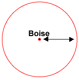
Imagine you are somewhere in the United States and you are totally, utterly lost; for whatever reason, you have absolutely no clue where you are. You find a friendly local and ask, "Where am I?" He says, "You are 625 miles from Boise, Idaho."
This is a nice, hard fact, but it is not particularly useful by itself. You could be anywhere on a circle around Boise that has a radius of 625 miles, like this:
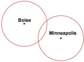
You ask somebody else where you are, and she says, "You are 690 miles from Minneapolis, Minnesota." Now you're getting somewhere.
If you combine this information with the Boise information, you have two circles that intersect. You now know that you must be at one of these two intersection points, if you are 625 miles from Boise and 690 miles from Minneapolis:
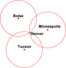
If a third person tells you that you are 615 miles from Tucson, Arizona, you can eliminate one of the possibilities, because the third circle will only intersect with one of these points. You now know exactly where you are: Denver, Colorado.
This process is called 2D trilateration because the points of intersection are all located on a two-dimensional plane. When we start getting height/altitude involved — hello, third dimension — 3D trilateration comes into play.
3D Trilateration
Fundamentally, three-dimensional trilateration isn't much different from two-dimensional trilateration, but it's a little trickier to visualize. Imagine the radii from the previous examples going off in all directions. So instead of a series of circles, you get a series of spheres.
If you know you are 10 miles from satellite A in the sky, you could be anywhere on the surface of a huge, imaginary sphere with a 10-mile radius. If you also know you are 15 miles from satellite B, you can overlap the first sphere with another, larger sphere.
The spheres intersect in a perfect circle. If you know the distance to a third satellite, you get a third sphere, which intersects with this circle at two points.
Earth itself can act as a fourth "satellite" or sphere; only one of the two possible points will actually be on the surface of the planet, so you can eliminate the one in space. Receivers generally look to four or more satellites, however, to improve accuracy and provide precise altitude information.
Advertisement
How GPS Devices Calculate Your Location
In order to function properly, a GPS device needs to know two things:
The location of at least three satellites above you
The distance between you and each of those satellites
GPS receivers figure both of these things out by analyzing high-frequency, low-power radio signals from the satellites orbiting the Earth. Better units have multiple receivers, so they can pick up signals from several satellites simultaneously.
Advertisement
Radio waves are electromagnetic energy, which means they travel at the speed of light (about 186,000 miles per second, or 300,000 km per second in a vacuum). The receiver can figure out how far the GPS signal has traveled by timing how long it took the signal to arrive.
Advertisement
GPS Math: Using Timing to Calculate Distance
A GPS satellite
Photo courtesy U.S. Army
At this point, you could confidently tell someone you want to impress that GPS works via trilateration. But you should be prepared for the follow-up question: How does the GPS device know the distance to those GPS satellites? As it turns out, it's a matter of timing.
At a particular moment (let's say midnight), the satellite begins transmitting a long, digital pattern called a pseudo-random code. The receiver begins running the same digital pattern also exactly at midnight. When the satellite's signal reaches the receiver, its transmission of the pattern will lag a bit behind the receiver's playing of the pattern.
Advertisement
The length of the delay is equal to the signal's travel time. The receiver multiplies this time by the speed of light to determine how far the signal traveled. Assuming the signal traveled in a straight line, this is the distance from receiver to satellite.
Maintaining Synchronicity
One major caveat is that the measurement only works if both the GPS unit and satellite have clocks that can be synchronized down to the nanosecond. This level of precision is only feasible with atomic clocks, but those cost between $50,000 and $100,000 a pop.
GPS satellites are already paid for by our tax dollars, but what about the GPS receivers? Even Apple would have a hard time selling iPhones at that price point.
Advertisement
The Global Positioning System has a clever, effective solution to this problem: Every satellite contains an expensive atomic clock, but the receiver itself uses an ordinary quartz clock, which it constantly resets.
In a nutshell, the receiver looks at incoming signals from four or more satellites and gauges its own inaccuracy. By constantly resetting and re-checking its time against the GPS signals coming from the satellites, a lowly smartphone gets atomic-clock accuracy "for free."
Advertisement
Differential GPS
GPS works pretty well, but inaccuracies do pop up. For one thing, this method assumes the radio signals will make their way through the atmosphere at a consistent speed (the speed of light).
But satellite signals are dealing with interference all the time. The earth's atmosphere slows the signals down, and large objects like skyscrapers can also affect their path.
Advertisement
Differential GPS (DGPS) helps correct these errors. The basic idea is to gauge GPS inaccuracy at a stationary receiver station with a known location. Since the DGPS hardware at the station already knows its own position, it can easily calculate its receiver's inaccuracy.
The station then broadcasts a radio signal to all DGPS-equipped receivers in the area, providing signal correction information for that area. In general, access to this correction information makes DGPS receivers much more accurate than ordinary receivers.
Advertisement
Frequently Asked Questions
What does GPS mean?
GPS stands for Global Positioning System. This means that, technically, saying "GPS systems" or "GPS system" is a redundancy.
How does GPS work on phone?
GPS works on a phone in pretty much the same way it does on other, older GPS devices. Now that most phones (as well as many vehicles and smart devices) are equipped with GPS functionality, it means that many people have a GPS unit on them at all times.
What are GPS and GIS?
GPS stands for global positioning system. It is a satellite-based navigation system that provides location and time information in all weather conditions, anywhere on or near the Earth's surface. GIS stands for geographic information system. It is a system designed to capture, store, manipulate, analyze, manage and present spatial or geographic data.
What is GNSS?
GNSS stands for global navigation satellite system. Technically, GPS is one or many global navigation satellite systems, such as Galileo in the EU (European Union) and China's BeiDou Navigation satellite system.
Cite This!
Please copy/paste the following text to properly cite this HowStuffWorks.com article: