How GPS Photo Taggers Work

By: Dave Roos
Flickr screenshot
If you upload your geotagged photos to Flickr, other people can see them and where you took them. See more pictures of essential gadgets.
HowStuffWorks

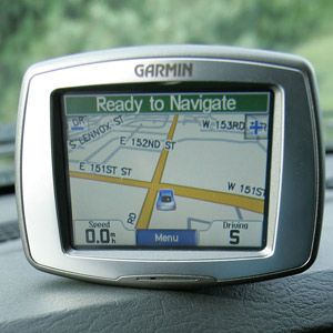
­Originally developed for the military, global positioning system (GPS) technology is now at the heart of some of our coolest consumer gadgets. GPS is the power behind onboard navigation systems in cars. It's what lets your cell phone know that you're at the corner of Main Street and Market. And most recently, it's what allows you to tag your digital photos with precise geographic information.

GPS photo tagging, also known as geotagging, is the process of embedding a digital photo with latitude, longitude and even altitude data. GPS photo tagging is one of the latest offshoots of a larger tagging movement that lets you categorize and organize content.

Advertisement

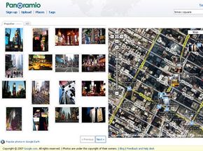
Instead of relying on a search engine like Google to tell us that a blog entry is about Bill Gates' campaign to eradicate malaria, the creator of the blog can tag the entry with the words "Bill Gates" and "malaria." The same goes for photos. On photo sharing Web sites like Flickr, users can tag their photos with information about who or what is in the photo and where is was taken ("San Francisco" or "Ames, Iowa"). Other users can search or browse by tags to find the most relevant content.

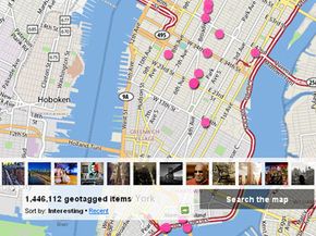
GPS photo tagging can cut down on the amount of work it takes to tag images on the Internet. If you upload a geotagged photo to Flickr, the Web site automatically loads your photo onto its interactive world map. Now other users can search for and view pictures taken in your precise geographic location.

GPS photo tagging also allows you to organize your personal photo library. In the past, when you wanted to search for a particular photo on your computer, you had to remember the date that it was taken. But if all of your digital photos are tagged with location information, then you can search your library for "Philadelphia" and see all of the photos that you've taken there.

GPS photo tagging also has professional applications. If you're a film location scout, you can accurately map all of the photos you took during a scouting trip to Ireland. Real estate agents can provide clients with an interactive photo map of all of their properties. Archeologists can link photos with other geographic information system (GIS) data when planning a dig.

Keep reading learn more about the mechanics of GPS photo tagging and some of the coolest geotagging applications.

Advertisement

Mechanics of GPS Photo Taggers

Flickr screenshot
You have to make your EXIF data visible in Flickr if you want your GPS tags to show up.
(c) HowStuffworks

When you take a photo with a digital camera, the camera records a lot more data than just the image. This information includes the time and date when the photo was taken, the orientation of the camera (portrait or landscape), whether a flash was used and even detailed camera settings like aperture, exposure and focal length. All of these data is stored in something called the EXIF header of the photo.

EXIF stands for Exchangeable Image File Format. EXIF headers provide a way of stamping photos with data that can read by other applications like photo management software or photo Web sites. This is how your computer automatically knows to put your photo in a folder titled February 28, 2009, and to rotate the image 90 degrees.

Advertisement

The cool thing about EXIF headers is that there's room to include longitude, latitude and altitude coordinates. In recent years, we've seen new hardware and software applications that can embed location data into EXIF headers using GPS technology.

To understand how this works, we'll walk you through the process for manually GPS tagging a photo using a standard digital camera and an inexpensive GPS receiver.

  1. Turn on your GPS receiver and your digital camera. Make sure that the clock on your camera is set to the same exact time as the clock on your GPS receiver.
  2. Set your GPS receiver to "tracking" or "log" mode. Your receiver will now record a running log of your location over a period of time.
  3. Carry your GPS receiver in a backpack or in your pocket as you take pictures throughout the day.
  4. After you upload your pictures to your computer, select the photos you want to tag with GPS coordinates. Note the exact time that each picture was taken (most photo management software will display this information).
  5. Go to your GPS tracking log. Write down the GPS coordinates associated with the time of each photo.
  6. Use EXIF editing software to enter the GPS information into the EXIF header of each photo.

Manually tagging each photo with GPS coordinates can be a bit labor-intensive. Also, even though there are plenty of free and shareware EXIF editors available online, there isn't a surefire solution that works every time on every operating system. As of this writing, iPhoto '09 from Apple is the only mainstream photo editing software that lets you manually add GPS coordinates to an EXIF header [source: Shankland].

Luckily, there are plenty of new hardware, software and Web applications that make it easy to tag your photos with GPS data and share them on interactive, online maps. Keep reading to learn more.

Advertisement

GPS Photo Tagger Applications

Panoramio screen shot
Panoramio is a Google-owned Web service that lets you share GPS-tagged photos and create photo maps.
(c) HowStuffworks

­One of the easiest ways to automatically tag your photos with GPS data is to buy a camera with a built-in GPS receiver. On the high end of the spectrum is a camera like the Ricoh 500SE, which is designed for GIS professionals. In addition to having a built-in GPS chip, this camera has the option of connecting via Bluetooth to a handheld GPS receiver for even more accurate readings. Every time you take a picture, the GPS data is written to the photo's EXIF header.

For amateur photographers, there are more and more compact, point-and-shoot digital cameras that have built-in GPS chips. There are even cell phones, like the Nokia N78, that have both a built-in camera and a GPS chip.

Advertisement

Another option is to buy a small GPS receiver that attaches to your camera. Nikon sells a small GPS photo-tagging device that attaches to the flash "shoe" on its higher end digital SLR models.

If you're looking for a GPS photo tagging solution that works with all digital cameras, then consider a small GPS tracker. Basically, you turn on the device, put it in your pocket and take pictures all day. Before you upload the pictures to your computer, take out the camera's memory card and insert it in the GPS tracker. All of the GPS data is automatically written to each photo's EXIF header. Now you can upload as usual.

Another interesting gadget is the Eye-Fi Explorer, an SD memory card with a small WiFi radio transceiver. Though it doesn't receive signals from satellites like a normal GPS unit, the Eye-Fi Explorer talks to WiFi base stations that give it geographic information. This may be a solution if you're taking photos in a city, but won't work well out in rural or remote areas. Also, it's not as accurate as a GPS receiver would be [source: Gross].

There are a growing number of Web sites for viewing your geotagged photos on a map and sharing them with friends. Flickr is one of the most popular photo sharing sites for mapping photos. Even if your photos haven't been tagged with GPS data, Flickr lets you drag and drop your photos on a map to tag them with longitude and latitude coordinates. Keep in mind, however, that you have to do this manually. Flickr isn't using the information from the images' EXIF header.

If you want to upload previously geotagged photos to Flickr, you have to go to your account settings and switch the "Import EXIF location data" tab to "yes." Flickr sets the default answer to "no" to protect its users' privacy. Now Flickr will automatically load all of your GPS-tagged photos on its map view. You can also create smaller maps to share with friends.

Two other photo Web sites, Picasa and Panoramio -- both owned by Google -- not only allow you to upload photos and create interactive photo maps, but they let you view and share photos using Google Earth. Google Earth is a free software application that allows you to zoom in and search 3-D satellite images on a virtual globe.

Picasa and Panoramio both give you the option of creating a .kml file from your uploaded photos or entire albums. If you imagine Google Earth as a kind of Web browser, then .kml files are like HTML files [source: Google Earth User Guide]. Google Earth reads a .kml file and displays your photos in their exact geographic location on its virtual planetary surface. Even better, you can share your .kml files with friends.

For lots more information about digital cameras and travel gadgets, follow the links on the next page.

Advertisement

Lots More Information

Related HowStuffWorks Articles

Sources

  • Google Earth User Guide. "About KML" (February 18, 2009)http://earth.google.com/userguide/v4/ug_kml.html
  • Gross, Matt. The New York Times. "Photo Geo-Tagging On the Cheap." February 18, 2009 (February 18, 2009)http://frugaltraveler.blogs.nytimes.com/2009/02/18/photo-geo-tagging-on-the-cheap/#more-121
  • Managing the Digital Image. "Understanding EXIF." March 15, 2007 (February 18, 2009)http://managingthedigitalimage.com/2007/03/15/understanding-exif/
  • My Digital Life. "GPS to Geotag Pictures in Cameras" (February 19, 2009)http://www.mydigitallife.info/2008/12/26/gps-to-geotag-pictures-in-cameras/
  • Ricoh. "Geo-Imaging" (February 18, 2009)http://www.ricoh-usa.com/solutions/solution_features.asp?pCategoryId=85&pSubCategoryId=81&pProductId=761&pCatName=Camera+Imaging&pSubCatName=Ricoh+500SE+Imaging+Solutions&pProductName=Geo%2DImaging&tsn=Ricoh-USA
  • Shankland, Stephen. CNET. "What's the best Web site for geotagged photos?" January 10, 2008 (February 19, 2009)http://news.cnet.com/8301-13580_3-9847536-39.html
  • Shankland, Stephen. CNET. "iPhoto update helps show merit of geotagging." January 6, 2009 (February 19, 2009)http://news.cnet.com/8301-13580_3-10133310-39.html

Advertisement

Loading...